

|
|||||||||||||||||||

Vector formatsThe program supports the following vector formats for its output files:
Some formats have restrictions for some types and properties of objects to be saved; those restrictions derive from the objects' internal design and purpose. Differences between formats are presented in the summary table below.
Notes:ArcView Shapefiles (SHP)
This format does not support arcs and circles; therefore, they are
replaced with contours with some approximation.
Contours with a z-coordinate are saved to an additional set of the shape files with the "_3d" suffix in the file name:
This format has the following settings: 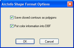 Closed contours (polygons) can be saved to an additional set of the shape files with the "_p" suffix in the file name:
Contour color data can be optionally saved as an additional field to the dbf file. The field name: "COLOR_RGB", record format: RRGGBB as hexadecimal. MapInfo MID/MIFSaving to this format creates these two files:
This is the only format that can save the latitude/longtitude degrees upon coordinate referencing. Windows Metafile (WMF)Restrictions: supports integer coordinates (16 bits) only; therefore, saving data with coordinate anchor in this format is generally impossible. Vector objects are saved in the raster coordinates system. Windows Enhanced Metafile (EMF)Restrictions: supports integer coordinates (32 bits) only; therefore, saving data with coordinate anchor in this format is generally impossible. Vector objects are saved in the raster coordinates system. ASCII XYZASCII XYZ is a plain-text format. Each line represents a contour's point in the following format: X_coordinate Y_coordinate Z_coordinate N_contour_number If no Z-coordinate is set for a contour, the field will be set to 0. All contour points follow one another and have the same contour number. We cannot guarantee that contour number will increase exactly by one 1 but we can guarantee that each contour number will be unique. If the vectorized set of vector objects has not been edited manually, and the number of contours has not changed, contour numbering will begin at 1 and continue incrementing by 1. The XYZ format does not provide saving arcs and circles, so they are simply ignored during saving. |